Two Fourteeners in One Day
The Two Fourteener Accomplishment
Summiting Two Fourteeners is a fun (albeit arduous!) accomplishment with a gorgeous vista as your payoff. Plus, bragging rights as summiting one Fourteener is usually considered a major accomplishment.
The tallest mountains in the Rockies, known as fourteeners due to their summit elevations of over 14,000 feet, are some of the crown jewels of Colorado. There are more than 50 named fourteeners in Colorado, some of which are the subject of debate due to their prominence from nearby peaks, and conquering them is a popular pastime for hikers and climbers, especially during the summer and early fall before the snow comes. Whether you’re looking to bag two fourteeners in one day or just looking for bragging rights. There are quite a few multi-fourteener routes you can use to knock two or more off your list in a single hike.
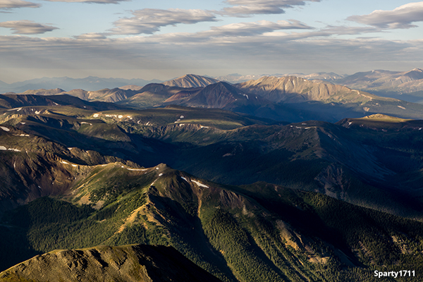
 A view of steep north slopes of Grays Peak (14,270 ft), seen from the summit of Torreys Peak (14,267 ft).
Two Fourteeners in One Day List
Grays & Torreys
Route: 8 miles, 3,600 ft elevation gain
Difficulty: Class 2
Grays and Torreys is a classic twofer, and since it’s conveniently located not far from the Bakerville exit on I-70, it’s highly popular with the Front Range crowd, and very heavily trafficked, especially on weekends. The road to the summer trailhead is infamously bumpy, so low-clearance cars might want to consider parking at the winter trailhead, though it will add about three miles onto your trip in each direction (on busy days you might be able to catch a lift from a friendly fellow hiker!). To summit both peaks, most people take the Grays Trail to the summit of Grays before descending on the north side of the mountain to cross the saddle to Torreys (.8 miles).
The DeCaLiBron
Route: 7.6 miles, 3,300 elevation gain
Difficulty: Class 2
What’s that? You’re not impressed with bagging only two fourteeners in one trip? Well, try the DeCaLiBron on for size, because this 7 mile loop near Alma will let you summit not one, not two, not three, but four fourteeners. (Okay, so Mount Cameron doesn’t technically count as its own mountain because it doesn’t have enough prominence from Lincoln, but we’re going to count it anyway because it sounds more impressive.) Now, when you’re tackling the DeCaLiBron, there’s one big decision you’ll have to make—do you start with Mount Democrat, and have to deal with the brutally steep descent down Bross at the end, or do you start with that same brutally steep grade but as an ascent and go up Bross, thus doing the loop counterclockwise? Both have their merits, but starting with Democrat tends to be the more popular choice. It should also be noted that the summit of Mount Bross is private property, so while the trail passes within a couple hundred feet of the mountain’s peak, it does not actually lead to the top of that particular mountain.
Shavano – Tabeguache
Route: 11 miles, 5,600 feet elevation gain
Difficulty: Class 2
This out-and-back trail is another popular two Fourteeners located near Poncha Springs. The summit of Shavano is about 4.5 miles from the trailhead, and Tabeguache is another mile from there. The trail is a pretty steady incline the entire way, so make sure to bring poles if that helps you. You’ll have views galore from both of these peaks, but like all 14ers, Shavano and Tabeguache are very exposed, so make sure to keep an eye on the weather and hike early to avoid thunderstorms because once you’re on Tabeguache, the only way back down is to first get back up to the top of Shavano.
Evans – Bierstadt via the Sawtooth
Route: 10.25 miles, 3,900 elevation gain
Difficulty: Class 3
Bierstadt and Evans are both considered pretty easy fourteeners in the Front Range (you can drive to the summit of Evans during the summer), and the two Fourteeners are not far apart, distance-wise, but the saddle that connects them, known as the Sawtooth, is not for beginners. This rocky saddle requires class 3 climbing skills, as you’ll boulder and scramble your way from one mountain to the next, but the views from each peak are certainly worth the effort.
Harvard – Columbia
Route: 15 miles, 6,100 elevation gain (Yeah, you read that right)
Difficulty: Class 2
Both Mt. Harvard and Mt. Columbia, near Buena Vista, are fairly straightforward on their own, and since they’re only about 3 miles apart, they’re a popular duo for peak baggers looking to grab more than one fourteener in a single hike, but you should definitely take note of those trail notes, because while Harvard – Columbia doesn’t require you to do any technical climbing or death-defying balancing acts, it is a LONG hike and should not be attempted unless you’ve got experience, come prepared, and know what you’re getting yourself into. Plenty of scree along the way makes this hike even more tedious, but if you feel up to the challenge, we guarantee you’ll feel an unbeatable sense of accomplishment when you’re done.
Redcloud – Sunshine
Route: 12.25 miles, 4,800 ft elevation gain
Difficulty: Class 2
There are a couple of ways to bag both Redcloud Peak and Sunshine Peak together, including a loop trail, but the easiest, safest way is to summit Redcloud, then Sunshine, and then backtrack to Redcloud. (There is also a trail that heads back down into the basin from the saddle on your way back down from Sunshine if you don’t want to summit Redcloud again, but be very careful as the footing can get tricky and dangerous.) This pair of mountains is located near Silverton, and the trail is well-maintained and much less crowded than some of the more popular 14ers in the Rockies.
Castle – Conundrum
Route: 14.5 miles from trailhead, 8 miles if you have 4WD and high clearance
Difficulty: Class 2, bordering on Class 3
Near Aspen, Castle and Conundrum peaks are absolutely stunning. You’ll see alpine lakes wildflowers, and since you’ll be right in the heart of the central Rockies, gorgeous peaks as far as the eye can see. The trail for Castle and Conundrum passes through the Maroon Bells – Snowmass Wilderness Area, some of the prettiest nature in Colorado. As for the hike itself, be prepared for steep terrain, loose rock, and even a false summit. If you have a regular passenger vehicle, Castle & Conundrum can make for a very long day of hiking, but if you have a 4WD vehicle with high clearance, you might want to consider taking Forest Road past the trailhead parking lot another few miles up to 12,800’ elevation, where you’ll have quite a bit of a head start.
Belford – Oxford
Route: 11 miles, 5,800 feet elevation gain
Difficulty: Class 2
You can reach the trailhead for Belford and Oxford from either Leadville or Buena Vista, making it pretty accessible for many Coloradans. The trail for Mt. Belford is pretty obvious, and once you summit it, getting to Mt. Oxford is also pretty straightforward via the saddle. But despite what it might look like, that descent from Mt. Belford is not easy, so take your time on the saddle. There are a lot of peakbaggers out there who use Belford and Oxford as an opportunity also to nab nearby Mt. Missouri, though be warned this will bring your round trip up to more than 16 miles, and your elevation gain up over 7,200’.
Bagging Two Fourteeners
When it comes down to it, there are a lot of 14ers you can combine into one trip, certainly more than just the ones on this list. Other popular routes include the Chicago Basin Peaks (Sunlight, Windom, and Eolus); Kit Carson & Challenger Peaks; and Blanca & Ellingwood. If you really want to get into the spirit of things, try adding 13ers to your list, and a whole new world of mountaineering will open to you.
No matter where your adventures take you, make sure to be prepared with food and water, proper equipment, clothing, and footwear, and a firm knowledge of your route and weather conditions. If you’ve never done a fourteener before, start small and build your way up to the more challenging ones—they will be waiting for you when you’re ready.
By Emily Krempholtz


